
A Historical Gazetteer of Places Named Liberty in Iowa
Iowa has a lot of place names that invoke the values of patriotism and freedom. Plymouth County, for instance, has its America Township. There is an Independence Township in Jasper County. Hamilton County has a Freedom Township. But among this type of place names, the most by far are named Liberty in some form or another.
This gazetteer reports 53 place names in Iowa using the word Liberty or a close variant. Cities, abandoned towns, townships, cemeteries, churches, and schools all invoke the word. The U.S. Census Bureau lists four cities in Iowa named Liberty or similar, the most of any state. Libertyville, North Liberty, New Liberty, West Liberty are counted in the decennial census. However, at one point there were at least nine towns or cities that were named after Liberty in Iowa. Three were named Liberty. The other two not mentioned already include the variants Liberty Center and South Liberty. There are 21 counties that have civil townships named Liberty and 22 cemeteries with Liberty in the name. At least 18 schools and nine churches are named Liberty. Many of the schools and churches are named after another known place name—such as a city, townsite, or civil township, and are not an independent instance of the use of the name. Not all of them are not listed here.
We all can wonder at the outpouring of support for liberty in Iowa’s history. Iowa place names were chosen in a combination of ways over the decades during which counties were organized. This period extended mostly from 1834 to 1882. There is one township that was renamed Liberty around World War I.
Townsite names were picked by one or more settlers of that area. Sometimes place names were named after a post office location but many times a place name conflicts with the post office name.Township names were voted on by the Board of Trustees, or later the County Board of Supervisors.
The use of liberty could of course be a patriotic gesture in the sense of the American freedom gained being a sovereign state freed from the burden of taxation without representation. The Declaration of Independence states that among the rights inseparable to people are “Life, Liberty and the pursuit of Happiness.” The authors of the US Constitution state in the preamble that the document is intended to “secure the Blessings of Liberty.” Further, no person may be “deprived of life, liberty, or property, without due process of law.” Along these lines, a driving factor to name places after liberty may have been the same social forces that lead to the Iowa state motto on the state seal, adopted in 1847: “Our liberties we prize and our rights we will maintain.” This motto is featured on the ribbon on the state flag.
There are, however, numerous additional factors that could have contributed to this vigorous sense of liberty. Many new residents of Iowa sought a life less bound by adherence to the established powers of any government, but especially the central US Government. The majority of politicians during the first period that Iowa counties were organized, 1834 to 1840, were Democrats and at that time they had little trust in institutions that put other people in charge, including banks and corporations. During the 1840s, the political tenor of Iowa changed with a shift toward Republican leadership at the state level and liberty took on other meanings at the local level, especially regarding slavery—either for or against. Some Iowans’ attitudes about government interference remained strong throughout the period of township formation but especially before the Civil War. Following the Civil War saw a large number of European immigrants coming to Iowa looking for opportunity or avoiding military conscription religious intolerance, or poverty. Their attitudes may have influenced some place names.
Sometimes a place name was carried west with immigrants moving to Iowa from an eastern township or place named Liberty for various personal reasons. For instance, there are West Liberties in Kentucky, Ohio, and Pennsylvania. There is a Libertyville in Illinois and also one in Alabama. Indiana has a North Liberty. There is a Liberty Center in Ohio. There are also at least 10 towns named Liberty in the East.
Despite the use of cardinal directions in many of the liberty names, liberty place names in Iowa reflect a potential geographic relationship to one another only rarely if at all. New Liberty is west of West Liberty, for instance. South Liberty may have been founded a year before North Liberty.
We probably will never know why all the liberty names were chosen. This is for a number of reasons. The biggest is there simply is a lack of information that has survived. Published plat maps and atlases as well as written histories did not become common until well into the last half of the 19th century.
Complicating things, many county histories and plats were written for patrons of those services. If you subscribed to a plat or atlas that catered heavily to its patrons, you stood a better chance of being recorded when you paid into the publication. Towns with more subscribers were sure to be put on the map. Conversely, even in more comprehensive publications, smaller communities did not attract the same level of attention of the publishers who compiled county histories. This is partly because fewer people meant there was less to record, but also there were fewer subscribers. Most publishers of county histories worked at a distance from the communities that were the subject of their writing and often relied on a standard template of US and State history flushed out with local details as readily available. Seventy-eight percent or 21 of the county histories consulted were published out of state and of the six that were not, only one was published in the same county that the history covered in the publication. Atlases are somewhat better where 47 percent of those consulted were made in state and two were from the same county as the subject maps. Although there is some expectation for this, a small community would not have printers and engravers, there are issues with the lack of familiarity with a locality. Publishers took accounts from someone in a larger town in a county to complete their histories, and these contributors often go without credit. A contributor from a smaller town may have had more to add about a locality, but typically they were not included to the same extent as those from the largest communities.
Another factor is that the county histories and atlases were published in an era of boosterism where it was the intent to show the progress of Western civilization as it extended from Classical Greece and Rome directly to the then modern era. Many Iowa communities were established early and remained small, sometimes even fading away. There was little room to be spared in type-set print for towns that weren’t showing the desired narrative of the great progress of “the American People.”
Additionally, the loss of information over time is just a factor of time passing. Even in those communities that still exist, we do not have a complete record of all the events and persons involved in the local history. For example, it is not known today exactly who Wright County was named for. We can’t hope to find records from meetings held long ago when entire sets of county records have suffered loss due to neglect, fire, and the like. We rarely know who even attend such meetings or when the meetings occurred let alone what any debate on the naming issues might have been. And even if we had a perfect record, historians must select what facts to present. This selection introduces bias as well.
One final note. This web post provides a demonstration of the use of maps, an aerial photo, historical accounts, and databases to reconstruct locations for long lost places as well as to dig into the potential meanings of place names. Not any one source provided the set of information given here. More information on the methods used in this post follows the historical gazetteer.
Historical Gazetteer
Local Places
Nine Iowa towns or cities, existing or abandoned, have been named after the concept of liberty. Four are cities today and are incorporated with a charter setting out their form of government. One is part of another city. One is an unincorporated town. The others are just traces of former ambitions to develop land that are now all but lost to history. Their sometimes complex histories follow in alphabetical order.
Local Places Named Liberty in Iowa
| Place | Township | County | Founded | Latitude | Longitude |
| Liberty | Liberty | Clarke | 1855 | 41.1452736 | -93.6541064 |
| Liberty | Liberty | Marshall | 1857 | 42.1502639 | -93.1568710 |
| Liberty | Liberty | Wright | 1855 | 42.7347080 | -93.9201630 |
| Liberty Center | Liberty | Warren | 1875, 1867* | 41.2043016 | -93.4999210 |
| Libertyville | Liberty | Jefferson | 1845 | 40.9579112 | -92.0490850 |
| New Liberty | Liberty | Scott | 1909 | 41.7178039 | -90.8790370 |
| North Liberty | Penn | Johnson | 1857 | 41.7430290 | -91.6078070 |
| South Liberty | Liberty | Johnson | 1857 | 41.5572410 | -91.5848880 |
| West Liberty | Wapsinonoc | Muscatine | 1838, 1856** | 41.5713891 | -91.2611100 |
* post office established in 1867
**date townsite moved
Liberty, Clarke County
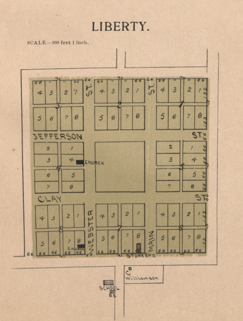
The town of Liberty, Clark County was platted in 1855. The town no longer exists. Liberty straddled the section-corner of Sections 5, 6, 7 and 8 of Liberty Township. A 1902 plat map shows the town as having a central square with eight blocks surrounding it. Each block had eight lots. Three buildings were labeled. These included two churches and a general store. The post office was in the same building as the store. The occupied lots were Lot 4, Block 4; Lot 8, Block 8 and the post office in Lot 8, Block 7. Liberty Cemetery is about a quarter mile south of the townsite.
Liberty, Marshall County
The 1878 county history states that a plat for the town of Liberty in Marshall County was made in 1857. The town was located in the northeast corner of section 27, Liberty Township. A post office was established at that location from 1857 to 1864. The community appears to have never grown substantially and only remains as a church that was listed in the 1912 county history with the affiliation of the Religious Society of Friends (Quakers). The nearby vicinity later became Bevins Grove, which was the name of the post office in 1875 and was recorded in 1878 as an “unsurveyed hamlet.” Such settlements were once more common across Iowa.
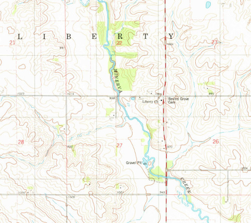
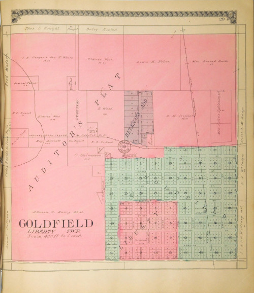
Liberty, Wright County
The founding of Liberty in Wright County is fairly complex. Liberty was platted in 1855 in Section 33, Liberty Township. This is the same site as the post office known as Goldfield that was established a year later in 1856. Liberty served as the county seat from 1858 to 1865. The original county seat for Wright County was chosen to be at Eagleville, which was also platted in 1855. However, Eagleville was never built and the location of the county seat was changed to Liberty in 1857. In 1866, the county seat was again changed when it was removed to the current location in Clarion. Voters on the issue apparently chose Clarion because it is geographically central to the county. The vote is reported to have been quite close and almost retained the county seat in Liberty. By 1875, Goldfield was shown as the name of the community. County plats record the earlier town within the town.
Liberty Center, Warren County
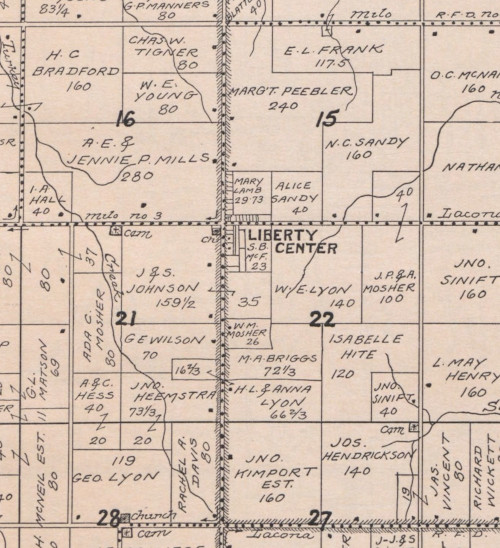
Liberty Center is an unincorporated community in the southwest corner of Section 15 and northwest corner of Section 22, Liberty Township, Warren County. It is indeed located in the center of the township. A post office was established in 1867 and the town was platted in 1875. In the 1872 county atlas, Liberty Center consisted of eight lots at the southeast and northeast corner of the junction of two county roads. A post office was located there at the time and continues to 2021. A bank opened in 1907. In 1915, the town had expanded north and a church and cemetery were located nearby to the west. The population was seventy-four. North Liberty School was located two miles north, in the northern area of the township. Liberty Center Cemetery is located one-half mile west of the town. The 1908 county history states the name of Liberty Township in Warren County was selected for the abolitionist views of its early residents. There are also Liberty Centers in Ohio and many Iowa abolitionists moved to the state from Indiana and Ohio.
Libertyville, Jefferson County
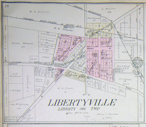
Libertyville is a city located at the section-corner of Sections 7, 8, 17, and 18 of Liberty Township in Jefferson County. It was platted in 1845 in an area previously known as The Colony. The town was located on the Iowaville Road and Agency Road, two territorial period roads. It was situated on the Chicago, Rock Island, and Pacific railroad as well as the Chicago, Burlington & Quincy railroad. The original town plat consisted of two blocks. By 1909, there were five land additions. In addition to the post office, there was a hotel, a bank, two train depots, an elevator, a school and two public squares. The hotel was actually outside of the platted limits of the town, as was the CB&Q depot and elevator. The reader can draw their own conclusions about any liberties potentially taken here.
New Liberty, Scott County
The City of New Liberty is a small incorporated area located in the south half of Sections 19 and 20, Liberty Township, Scott County. The community, like most of Scott County, was largely Prussian and German immigrants. In this instance, many were from Holstein. Jacob Heller was the first Euro-American to settle in Liberty Township in 1837. But New Liberty wasn’t founded until much later, apparently when the Burlington, Cedar Rapids & Northern railroad was built. The town was incorporated in 1909. George Lueders was the first mayor and otherwise prominent resident.
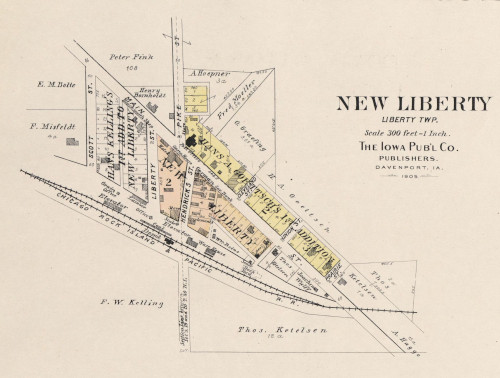
County atlases depict the town as a few blocks running along the railroad alignment, which was the Chicago, Rock Island, and Pacific railroad in 1905. The town also was situated along a local road that ran diagonally northwest to southeast. Two additions had been made to the town by 1894. Shown along the railroad siding were the depot, lumber and coal storage, two scale houses, a warehouse, two elevators, and a stockyard. The local post office and a hotel also were present. Among the businesses were the German Saving Bank, opera house, two saloons, a blacksmith and harness shop, a farm implement and lumber company, and a separate hardware and lumber store. The H.O. Seifert Company opened a branch in the community. H.O. Seifert sold various wares and goods including coal, lumber, hardware, tile, and sun-proof paint.
The New Liberty cemetery is located about a mile north of the current city in the northeast quarter of Section 19. This suggests an earlier settlement could have been located near there, and if so, it was later moved with the arrival of the railroad. This assertion is partially supported by the location of the New Liberty post office about a mile from the cemetery along the Tipton Road—later New Liberty Road, in the northwest corner of Section 19 in the 1875 statewide Andreas atlas. At that time, the atlas recorded a black smith shop at the current location of the City of New Liberty. In the 1894, Scott County atlas, New Liberty is shown at its current location.
The further possibility for movements of the town, resulting in the name New Liberty, is intriguing. The Big Rock Cemetery has an alternate name of Old Liberty Cemetery. The townsite of Big Rock exists as an unincorporated place in 2021. This village was founded in 1855, well before New Liberty, and had its own rail connection on the Davenport and St. Paul Railroad by 1875. The 1882 county history mentions that the townsite had been the location of an earlier settlement. Perhaps the earlier settlement at Big Rock was the original Liberty of Liberty Township.
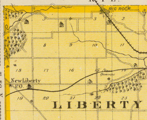
Showing New Liberty, New Liberty Cemetery, Big Rock, and
Big Rock (Old Liberty) Cemetery, 1875
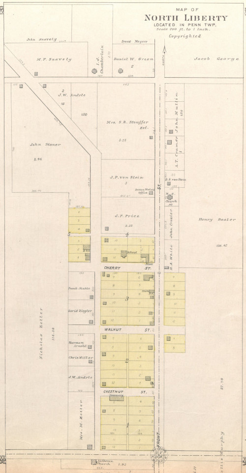
North Liberty, Johnson County
The City of North Liberty is located in Penn Township, Johnson County. John Gaylor and A.C. Denison took out claims for the future platted area of North Liberty in 1838 in Section 12 of the township. David Crozier had settled in the vicinity of the future North Liberty plat. In 1843, Crozier’s former cabin became the first school. The area was known variously as Big Bend, Big Bottom, or North Bend owing to the flat valley floor or bottom land surrounding a major turn in the course of the Iowa River northwest of the future city.
Francis Bowman surveyed the town plat in 1857 and the town was named North Liberty at that time. In 1860, the first frame school was built after the Crozier cabin burned. In 1904, a savings bank was established. North Liberty incorporated on November 10, 1913 when its population was approximately 190. At this time there was the brick bank, a number of wood clad store buildings, a grain elevator, and an Interurban rail station.
South Liberty, Johnson County
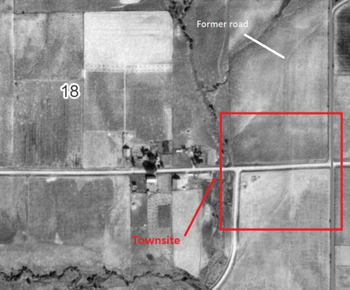
South Liberty was a village located in Section 17, Liberty Township, Johnson County. This is about two and quarter miles west and a half mile north of Hills. Liberty Township was organized in 1846. Vincent Gross platted South Liberty in either 1856 or 1857 at the location of the Bon Accord Post Office. Gross was a Frenchman whose father fought in the French imperial army under Napoleon for twelve years. The atlas of Johnson County from 1900 shows South Liberty to consisted of four blocks with eight lots each.
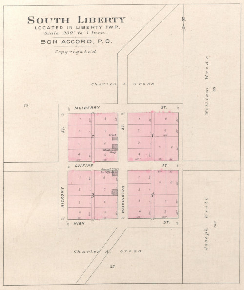
The Bon Accord post office and general store were located in a building on Lot 8, Block 3 at the southeast corner of Guffins and Washington Streets. A mill and a separate building for a blacksmith shop were located in Lot 6, Block 2 facing Washington Street. A fourth unnamed building was shown in the lot south of the general store and post office. That might have been a saddle and harness shop in 1882. In that year, Charles Rede was the general store owner. The Bon Accord post office was in service from 1859 to 1897, and then it was known as South Liberty until sometime before 1912 when the post office was reported abandoned. South Liberty continued to be shown on plats until about 1939, but 1930s aerial photos indicate the village was entirely gone by that point.
West Liberty, Muscatine County
The City of West Liberty is located in Wapsipinoc Township, Muscatine County. It is the name of two different townsites in the township. West Liberty was founded in 1838 by Simon Bagely, who ran the first post office by the name West Liberty. The name was reportedly chosen for a place “back east.” The old town, which was surveyed and platted when it was established, had been located “a little northwest” of the 1911 extent of the town. This may be at about the northwestern edge of the present City of West Liberty, however the location is not recorded in the available county plat maps and atlases. North Prairie Cemetery is about 1.25 miles north of the present northwest corner of the city or 2.10 miles north of the railway. It’s first burial was in 1838.
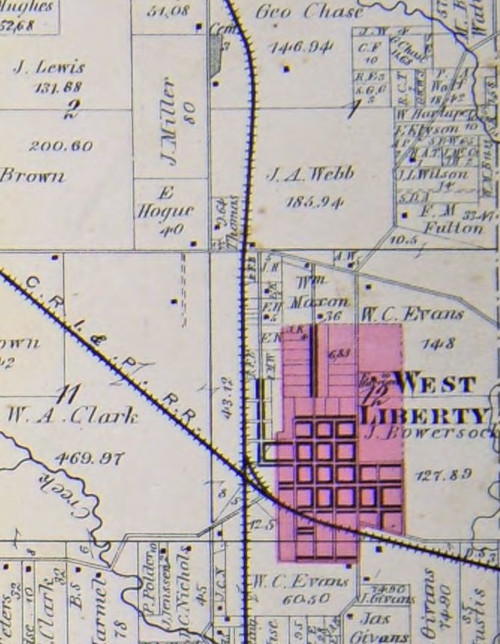
In 1856, John M. Spencer and T. J. Robinson of Rock Island and J. W. Clark of Iowa City relocated the town to be near the east-west route of the Chicago, Rock Island, and Pacific railroad. This was the new location for the town.
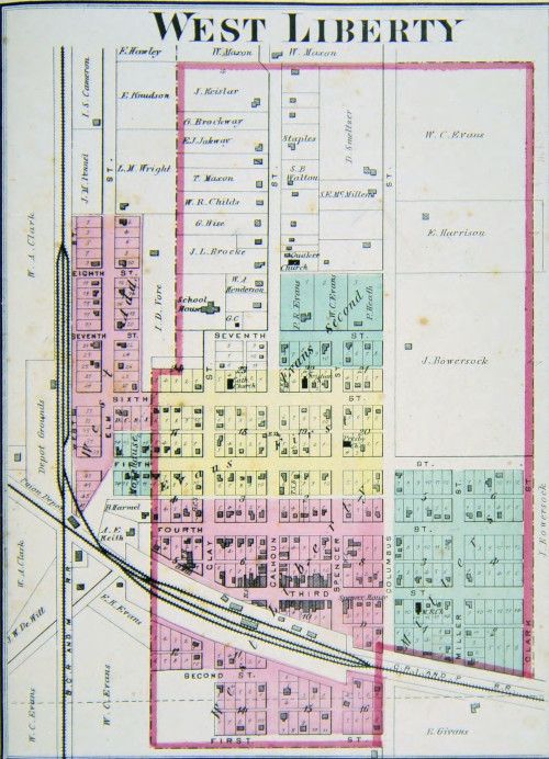
When the Burlington, Cedar Rapids & Northern railway was built running north-south it formed a junction at West Liberty. That railroad was founded in 1876. West Liberty was incorporated in 1868. A bank was founded in the same year. In 1879, West Liberty had a paper named The Enterprise in publication from 1869 to 1893. West Liberty has the fairgrounds for the Muscatine County Fair, which is unusual for Iowa where the fairgrounds tend to be located in the county seat. A fair was first held in Wapsininoc Township in 1862. The fairgrounds in West Liberty were established in 1875.
An earlier nearby settlement, known as Wapsinonoc, was settled in 1836. That settlement shared the name of the township with a creek in the area. Wapsipinoc settlement was located about two miles west of West Liberty and along the alignment of US Highway 6, a location marked as an agricultural field in the 1836 Government Land Office survey of the township.
Townships
There are 21 counties with Liberty Townships. Many, but not all, have an associated townsite or other feature, such as a cemetery. The date organized for most is taken from a relevant county history. Reasons for naming townships is sparse. Liberty Township in Warren County was selected for the abolitionist views of its early residents. Liberty Township in Hancock County was organized as German Township, but was renamed due to anti-German sentiment related to the First World War. Mills County had a West Liberty Township that was changed to Glenwood Township in 1857.
Townships Named Liberty in Iowa
| Township | Organized | Associated Places | Latitude | Longitude |
| Buchanan | 1847 | 42.4267859 | -91.7725452 | |
| Cherokee | 1870 | Liberty, cemetery | 42.8665056 | -95.6815636 |
| Clarke | 1854* | Liberty, town Liberty, cemetery | 41.1178092 | -93.6152452 |
| Clinton | 1844 | 41.9022111 | -90.8400534 | |
| Dubuque | 1849 | 42.6025313 | -91.074403 | |
| Hamilton | 1882 | Liberty Center, cemetery | 42.4273062 | -93.6401699 |
| Hancock | 1878, ca. 1918** | Liberty, cemetery | 43.0391917 | -93.6751072 |
| Jefferson | 1841 | Libertyville, town | 40.9380700 | -92.0138907 |
| Johnson | 1846 | South Liberty, town | 41.5544697 | -91.5621058 |
| Keokuk | 1854 | 41.4675812 | -92.0055214 | |
| Lucas | 1852 | 41.1170004 | -93.3847605 | |
| Marion | 1846 | Liberty, cemetery | 41.2045906 | -92.9274535 |
| Marshall | 1855 | Liberty, settlement | 42.1654574 | -93.1745437 |
| Mitchell | 1869 | Liberty, cemetery | 43.3919085 | -92.7296771 |
| O’Brien | 1869 | Liberty, cemetery | 42.9535110 | -95.5644274 |
| Plymouth | 1879 | Liberty, cemetery | 42.6921368 | -96.3902114 |
| Ringold | 1867* | 40.7684357 | -94.1859127 | |
| Scott | 1846* | Old Liberty, cemetery New Liberty, cemetery New Liberty, town | 41.7276602 | -90.8406015 |
| Warren | 1856* | Liberty Center, town Liberty Center, cemetery | 41.2045306 | -93.4999856 |
| Woodbury | 1868 | Liberty Township, cemetery | 42.3455730 | -96.3255568 |
| Wright | 1856 | Liberty, town Liberty, cemetery | 42.7756943 | -93.9122665 |
*1883 Census, **Name changed, see Andrews (1972)
Cemeteries
There are 22 known cemeteries with an associated name of Liberty or a variant in Iowa. The reasons for selecting cemetery names are various but often unknown. Some of the cemetery names match a township name, a townsite, or a church name. Thirteen cemeteries are in a township named Liberty, nine are not. Four match a townsite name, but all of these are in a township named Liberty. Just two known cemeteries are associated with Liberty churches.
Other reasons for cemetery names remain unknown. No information about how cemeteries were named has been found In the 29 county histories cited as well as others. Other avenues of research might be more useful but are as yet unknown.
One compelling idea is that some early cemeteries might be the result of former townsites that have been lost to time. A curiously large number of cemeteries, some 41 percent, are named Liberty or a variant but do not occur in a Township named Liberty. These offer a sense that a settlement may have once been located there. But this remains conjecture at this time.
The names and locations of Liberty cemeteries are listed in the following table.
Cemeteries Named Liberty in Iowa
| Name | Alternate Name(s) | Township | County | Latitude | Longitude |
| Liberty | Union | Adair | 41.1583688 | -94.2898317 | |
| Liberty | Cass Liberty Township | Cass | Boone | 41.8997070 | -93.8927280 |
| East Liberty | Liberty, Mount Hope | Sheridan | Carroll | 42.1593264 | -94.7638850 |
| North Liberty | Iowa | Cedar | 41.6852385 | -91.2290240 | |
| Liberty | Liberty Township | Liberty | Cherokee | 42.8369275 | -95.6363979 |
| Liberty | Liberty | Clarke | 41.1383432 | -93.6546635 | |
| Liberty | Herdland | Clay | 42.9898246 | -95.1417437 | |
| Liberty Center | Liberty Township | Liberty | Hamilton | 42.4345911 | -93.6410912 |
| Liberty | German Township Cemetery, Liberty Methodist Cemetery, Liberty Township Cemetery, Stille Cemetery | Liberty | Hancock | 43.0292670 | -93.6543626 |
| Rock Creek | Baptist Cemetery,Liberty Cemetery | Rock Creek | Jasper | 41.7383865 | -92.8236685 |
| Liberty | Liberty | Marion | 41.2294156 | -92.9428858 | |
| West Liberty | Oak | Mills | 41.0955550 | -95.7538960 | |
| East Liberty | Silver Creek | Mills | 41.0594420 | -95.6002800 | |
| Liberty | Little Cedar | Liberty | Mitchell | 43.3855176 | -92.7232360 |
| Liberty | Liberty | O’Brien | 42.9243228 | -95.5934706 | |
| Liberty | Perry, Liberty-Perry Township | Liberty | Plymouth | 42.6558189 | -96.3897420 |
| West Liberty | Sugar Creek | Poweshiek | 41.5740130 | -92.6433756 | |
| Big Rock | Old Liberty | Liberty | Scott | 41.7645569 | -90.8265543 |
| New Liberty | Liberty | Scott | 41.7344398 | -90.8796015 | |
| Liberty Center | Liberty | Warren | 41.2041026 | -93.5089713 | |
| Liberty Township | Township | Liberty | Woodbury | 42.3557299 | -96.3121360 |
| Glenwood | Goldfield, Liberty | Liberty | Wright | 42.7407879 | -93.9255232 |
Additional information on each cemetery follows. The 1875 and 1904 atlases are statewide. All other atlases are for the specific county.
Adair County. Liberty Cemetery. Union Township. The cemetery is not shown in 1875 but is shown next to a church in 1904.
Boone County. Liberty Cemetery, or Cass Liberty Township Cemetery. Cass Township. The cemetery appears in the 1875 atlas, at which time there were no roads to it.
Carroll County. East Liberty Cemetery, Liberty Cemetery or Mount Hope Cemetery. Sheridan Township. A school a half mile north was the location of the Liberty Independent school district in 1875, 1923, and 1930.
Cedar County. North Liberty Cemetery. Iowa Township. The cemetery appears in the 1875 Andreas atlas.
Cherokee County. Liberty Cemetery or Liberty Township Cemetery. Liberty Township. The cemetery is not shown in 1875 Andreas atlas but is shown in 1904 atlas.
Clarke County. Liberty Cemetery. Liberty Township. The cemetery is located a little over a half mile south of the town of Liberty. The Cemetery is shown in the 1875 atlas at a location about a quarter mile south of the townsite of Liberty.
Clay County. Liberty Cemetery. Herdland Township. The cemetery is not shown in the 1875 or 1887 atlas but is shown in the 1904 atlas.
Hamilton County. Liberty Center Cemetery. Liberty Township. Is not shown in the 1875 or 1904 atlas but does appear in the 1918 county atlas. Liberty Township was settled largely by first or second generation German immigrants.
Jasper County. Rock Creek Cemetery, Baptist Cemetery, or Liberty Cemetery. Rock Creek Township. The cemetery appears along with a farmhouse in the 1875 atlas.
Hancock County. Liberty Cemetery, German Township Cemetery, Liberty Methodist Cemetery, Liberty Township Cemetery, or Stille Cemetery. Liberty Township. The cemetery is not shown in the 1875 Atlas but is shown in the 1904 atlas. Liberty Township began as German Township but was changed during the first world war.
Marion County. Liberty Cemetery. Liberty Township. The cemetery appears in the 1875 atlas and the 1930 Marion County Atlas.
Mills County. East Liberty Cemetery, Silver Creek Township. The cemetery is associated with East Liberty Church, located directly north of the cemetery across Hutchings Avenue. The church is shown in the 1875 atlas and the graveyard is shown to the west of the church at that time. A mill is shown nearby to the west across Silver Creek. In the 1904 atlas, the cemetery is on the south side of the local road, which is where the cemetery is marked today. There are both East and West Liberty Cemeteries in Mills county, which is intriguing. Interestingly, there is no record of an East Liberty Township but the Board of Supervisors frequently revised township lines and perhaps names as well. West Liberty Cemetery is indeed to the west, if also north, in Oak township. Due west, West Liberty Township is now Glenwood Township.
Mills County. West Liberty Cemetery. Oak Township. The cemetery is not shown in 1875 but is shown in 1904. West Liberty Cemetery is northwest of East Liberty Cemetery and the East Liberty Church in Silver Creek Township. West Liberty Township was the township south of Oak, but is now Glenwood Township. A county is often organized at first with a few large townships. These are reorganized and portions taken out for new townships as the population grows. It is possible the early cemetery called West Liberty Cemetery was in fact in West Liberty Township but effectively separated from its namesake when Oak Township was organized. The 1881 county history details a fairly consistent reworking of the county township boundaries over time. See also Liberty Cemetery in Plymouth County below. In 1857, West Liberty Township was renamed Glenwood Township. As it stood at the time, West Liberty Township had the current size of Glenwood township. However, the lack of the cemetery being recorded in 1875 is problematic to this theory. County records prior to 1853 were lost, so confirming any reason for the name would be difficult now.
Mitchell County. Liberty Cemetery or Little Cedar Cemetery. Liberty Township. Little Cedar, Iowa is located a quarter mile south on Quale Avenue. In the 1875 atlas, Little Cedar Post Office is located at approximately the location of the cemetery. That post office was established in 1873. The first settlers arrived in the 1850s and the first death was in 1856 or 1858. In the 1904 atlas, Little Cedar was located in its present location and adjacent to the Chicago Great Western Railway. In 1911, the cemetery is shown in its present location.
O’Brien County. Liberty Cemetery. Liberty Township. The cemetery is not shown in the 1875 or 1904 statewide atlases but is shown in the 1911 O’Brien County atlas. One county history states few people settled in the township until construction of the Sioux Falls and Cherokee branch of the Illinois Central railroad was completed in 1887. The town of Calumet was platted at that time. However, people did live in the township before the railroad came. A German Hall is shown in the Township in the 1875 atlas.
Plymouth County. Liberty Cemetery, Perry Cemetery, or Liberty-Perry Township Cemetery. Liberty Township. In the 1875 Atlas, the cemetery is not shown and the township is given as Perry and it was a double-sized township with seventy-two sections. By 1904 the township had been divided and the north half consisting of thirty-six sections had become Liberty Township and the cemetery was shown in the atlas.
Poweshiek County. West Liberty Cemetery. Sugar Creek Township. The cemetery is associated with the West Liberty Church of Christ. The Diamond Trail Rd passing just north of the parcel was partially established as the Diamond Trail stage route before 1848 when gold rush traffic used the route. The road configuration has changed somewhat between 1875 and 1904. The church and cemetery show up in the 1904 atlas as well as current maps.
Scott County. Big Rock or Old Liberty Cemetery. Liberty Township. Big Rock is shown as a town in the 1875 Andreas atlas with a cemetery. Big Rock is shown on the Davenport & St. Paul Railroad. It was founded in 1855. It was also located on a stage coach route according to the 1882 county history. A county history states an early settlement was located near Big Rock prior to 1855. This was possibly known as Liberty.
Scott County. New Liberty Cemetery. Liberty Township. This cemetery does not appear in the 1875 atlas, while New Liberty is shown as a post office at the crossing of a road running northwest to southeast and an east-west road at northwest corner of Section 19. That road became known as the Tipton Road and then later New Liberty Road. In the 1894 Scott County atlas, New Liberty is shown as a town on the Tipton Road at the Burlington, Cedar Rapids and Northern railway in the southeast corner of Section 19. The cemetery is shown at its current location in that atlas.
Warren County. Liberty Center Cemetery. Liberty Township. The cemetery does not appear in the 1875 atlas and Liberty Center is shown as a post office. In the 1904 atlas the cemetery is shown.
Woodbury County. Liberty Township Cemetery or Township Cemetery. Liberty Township. The 1875 atlas shows a river channel scar and the rail alignment, directly to the east of which the cemetery was later located along with a local road now known as Benton Avenue. The cemetery is shown in the 1904 atlas and also on the the 1976 USGS Salix, IA-NE 7.5′ Quadrangle where it is named Township Cemetery, but it is not shown in the 1930 plat or 1875 atlas indicating the problem with tracking geographic features through time.
Wright County. Glenwood Cemetery, Goldfield Cemetery, or Liberty Township Cemetery. Liberty Township. The cemetery is currently located in the northwest quarter of Section 33 along a north south local road now known as Mill Street. The town of Goldfield is located to the southwest of the cemetery. Goldfield is shown on the 1875 Andreas Atlas, and in 1904 northern extension into the NE quarter of Section 33 is shown. By 1930, the cemetery was included in Goldfied outlots. Today the incorporated boundary of Goldfield includes the cemetery.
Churches
Sometimes an old place name may be discovered in the name of other institutions, such as churches. There are 10 churches in Iowa with Liberty in their name. Five of these are related to known cities, such as West Liberty and North Liberty and do not add information to where places with the name Liberty may have existed. Two churches, Union Liberty Church in Mahaska County and Liberty Baptist Church in Grundy County use Liberty as a name but not as a geographic indicator. The remaining three provide information of the location of other geographic features.
Churches of Interest Named Liberty in Iowa
| Name | Township | County | Latitude | Longitude | Associated Place |
| Liberty | Liberty | Marshall | 42.1502639 | -93.1568710 | village site |
| East Liberty | Silver Creek | Mills | 41.0602757 | -95.6005574 | cemetery |
| West Liberty | Sugar Creek | Poweshiek | 41.5744434 | -92.6432453 | cemetery |
Liberty Church and the associated cemetery in Marshall County is the only remaining sign of the village of Liberty.
East Liberty church in Mills County is associated with the East Liberty cemetery. Interestingly, there is no record of an East Liberty Township, but there had been a West Liberty Township, which is now Glenwood Township. County records prior to 1853 were lost, so confirming a name change or old townsite would be difficult.
West Liberty Church in Poweshiek County, is also associated with a cemetery by the same name and is still active. The church and cemetery are located along what was once known as the Diamond Trail, a historic route used by westward travelers and was the southern route of the Western Stage Company. In 1880, three farmers shared the West Liberty address in Sugar Creek Township. A hotel was located at this place from at least 1872 to 1875.
Schools
Schools of interest are mentioned earlier. A vast majority of schools in Iowa with the name Liberty don’t provide any useful details about a geographic place.
Methods
A number of resources are available for identifying place names in Iowa. The base dataset was obtained from the Geographic Names Information System (GNIS) database provided by the U.S. Board of Place names. Although a concerted effort has been made by others to provide basic information on Iowa counties and townships in Wikipedia, the GNIS dataset is far more inclusive than Wikipedia for geographic features smaller than townships. Additional information was gained from Mott (1930, 1931). Finally, two statewide atlases were used, supplemented by county atlas and plat maps, which are listed as sources. County histories were used for dates of townships, however there are discrepancies between these sources and the 1883 state census publication. When the two sources conflict, the county histories tend have more detailed knowledge. Some county histories do not give dates for organization of the townships. In this event, the 1883 published dates were used. In the specific case of Mills County, records for townships prior to 1853 are incomplete, according to History of Mills County, Iowa, 1881, p. 400. Two very good sources on Iowa geographical information are the Iowa Geographic Information Server at Iowa State University and the Iowa Digital Library at the University of Iowa, which includes the digitized version of the plat map and atlas collection from the State Historical Society of Iowa.
Sources
Andrews, Clarence A. A Literary History of Iowa, p.79. University of Iowa Press. 1972
A. T. Andreas’ Illustrated Historical Atlas of the State of Iowa. Chicago: Andreas Atlas Co. 1875.
Atlas of Johnson County, Iowa. Davenport: Huebinger Survey and Map Publishing Co. 1900.
Atlas of Mahaska County, Iowa. Knoxville, IA: Midland Map Co. 1905.
Atlas of Muscatine County, Iowa. Clinton, IA: Harrison & Warner. 1874.
Atlas of Scott County, Iowa. Davenport: Iowa Publishing Co. 1905.
Atlas of Scott County, Iowa. Davenport: Huebinger Survey and Map Publishing Co. 1894
Atlas of Warren County, Iowa. Marshalltown, Iowa: Harrison & Warner, 1872.
Atlas of Warren County, Iowa. Knoxville, IA: Midland Map Co. 1915.
Berdine, Richman. History of Muscatine County, Iowa. Chicago: S. J. Clarke Publishing Co. 1911.
Biographical History of Cherokee County, Iowa. Chicago: W. S. Dunbar. 1889.
Biographical and Historical Record of Clarke County, Iowa. Chicago: Lewis Publishing Co. 1886.
Biographical and Historical Record of Ringgold and Union Counties, Iowa. Chicago: Lewis Publishing Co. 1887.
Clark, Will and J. E. Noris. History of the Counties of Woodbury and Plymouth, Iowa. Chicago: A. Warner & Co. 1890
Combination Atlas Map of Johnson County, Iowa. Geneva, IL: Thompson and Everts. 1870.
Historic Auto Trails, Diamond Trail. Ames, IA: Iowa Department of Transportation. 2021. https://iowadot.gov/autotrails/diamondtrail
History of Buchanan County, Iowa. Cleveland, OH: William Brothers. 1881.
History of Dubuque County, Iowa. Chicago: Western Historical Co. 1880.
History of Hamilton County, Iowa. Chicago: S.J. Clarke Publishing Co. 1912.
History of Johnson County, Iowa. Iowa City, IA: [The Publishers]. 1883.
History of Jefferson County, Iowa. Chicago: Western Historical Co. 1879.
History of Keokuk County, Iowa. Des Moines, IA: Union Historical Co. 1880.
History of Kossuth, Hancock, and Winnebago counties, Iowa. Springfield, IL. Union Publishing Co. 1884.
History of Lucas County, Iowa. Des Moines, IA: State Historical Co. 1881.
History of Marshall County, Iowa. Chicago: Western Historical Press, 1878.
History of Mills County, Iowa. Des Moines, IA: Iowa Historical Co. 1881.
History of Mitchell and Worth counties, Iowa. Springfield, IL: Union Publishing Co. 1884.
History of Muscatine County, Iowa. Chicago: Western Historical Co. 1879.
History of Poweshiek County, Iowa. Des Moines, IA: Union Historical Co. 1880.
History of Scott County, Iowa. Chicago, Inter-state publishing Co. 1882.
History of Warren County, Iowa. Des Moines, IA: Union Historical Co. 1879.
History of Wright County, Iowa. Indianapolis: IN: B. F. Bowen & Co. 1915.
Huebinger, M. Atlas of the State of Iowa. Davenport, Ia: Iowa Pub. Co., Inc. 1904.
Iowa Digital Library. Iowa City, Iowa: University of Iowa Libraries, Special Collections and Archives. https://digital.lib.uiowa.edu/.
Iowa Geographic Map Server. Ames, IA: Iowa State University Geographic Information Systems Support & Research Facility. http://ortho.gis.iastate.edu/index.html.
Lee, Jesse. History of Hamilton County, Iowa. Chicago: S. J. Clarke Publishing Co. 1912.
Martin, W. History of Warren County, Iowa. Chicago: S. J. Clarke Publishing Co. 1908.
Mott, D. C. Abandoned Towns, Villages and Post Offices of Iowa, The Annals of Iowa 17(6), p.435-465. 1930. doi: https://doi.org/10.17077/0003-4827.5424
Abandoned Towns, Villages and Post Offices of Iowa, The Annals of Iowa 17(7), p.513-543. 1931. doi: https://doi.org/10.17077/0003-4827.5451
Abandoned Towns, Villages and Post Offices of Iowa, The Annals of Iowa 17(8), p.578-599. 1931. doi: https://doi.org/10.17077/0003-4827.6766
Abandoned Towns, Villages and Post Offices of Iowa, The Annals of Iowa 18(1), p.42-69. 1931. doi: https://doi.org/10.17077/0003-4827.5477
National Archives. Post Office Reports of Site Locations, 1837–1950: Iowa. Washington, DC: U.S. National Archives and Records Administration. https://www.archives.gov/research/post-offices/locations-1837-1950.html#iowa
Oldt, Franklin and Patrick Quigley. History of Dubuque County, Iowa. Chicago: Goodspeed Historical Association. 1911.
Parizek, Marlene, Mary Lou Wilson, and Pam Schnittjer. Genealogy Collection, North Prairie Cemetery. West Liberty, Iowa: West Liberty Public Library. 2011. https://www.wlpl.org/services/genealogy-collection/north-prairie
Peck, John, Otto Montsheimer, and William Miller. Past and Present of O’Brien and Osceola Counties, Iowa. Indianapolis, IN: B. F. Bowen & Co, Inc. 1914.
Plat Book of Marion County, Iowa. Rockford, IL: W.W. Hixson & Co. 1930.
Plat Book of Marshall County, Iowa. Minneapolis, MN: Warner & Foote. 1885.
Peters, Davi. Iowa Population Over 100 Years. Extension Community and Economic Development Publications 9. 2011. https://lib.dr.iastate.edu/extension_communities_pubs/9
Richman, Irving. History of Muscatine County, Iowa. Chicago: S. J. Clarke Publishing Co. 1911.
Secretary of State. Iowa Historical and Comparative Census: 1836-1880. pp. 424-610. Des Moines, IA: F.M. Mills, 1883. https://www.iowadatacenter.org/Publications/iowa18361880.pdf/view
Standard Historical Atlas of Hamilton County, Iowa. Chicago: George A. Ogle & Co. 1918.
Standard Atlas of Jefferson County, Iowa. Chicago: George A. Ogle & Co. 1909
Standard Historical Atlas of Mitchell County, Iowa. Chicago: Anderson Publishing Co. 1911.
Standard Atlas of O’Brien County, Iowa. Chicago: George A. Ogle & Co. 1911
Standard Atlas of Wright County, Iowa. Chicago: George A. Ogle & Co. 1912.
Stiles, C. The Great Seals of Iowa. The Annals of Iowa 11 (1915), 562-581. https://doi.org/10.17077/0003-4827.3971
United States Board on Geographic Names. Geographic Names Information System, Reston, VA: United State Geological Survey. 2021 https://www.usgs.gov/core-science-systems/ngp/board-on-geographic-names/download-gnis-data
United States Census Bureau Library, Infographics & Visualizations. Greetings from Liberty USA. Suitland, MD: United States Census Bureau. 2016. https://www.census.gov/library/visualizations/2016/comm/cb16-ff13_liberty_usa.html
USGS Store. State Center NW, IA 7.5′ Quadrangle. Reston, VA: United States Geological Survey. 1975. https://store.usgs.gov/product/53802
Salix, IA-NE 7.5′ Quadrangle. Reston, VA: United States Geological Survey. 1976. https://store.usgs.gov/product/53738
Little Cedar 7.5′ Quadrangle. Reston, VA: United States Geological Survey. 1972. https://store.usgs.gov/product/53486
Young, William. History of Marion County, Iowa, and Its People. Chicago: S.J. Clarke Publishing Co. 1915.
William Donnel. Pioneers of Marion County. Des Moines, IA: Republican Steam Printing House. 1872.
Wolfe, Patrick. Wolfe’s History of Clinton County, Iowa. Indianapolis, IN: B. F. Bowen & Co. 1911
